
Файл:Blue Like Mars.jpg

Исходный файл (2560 × 1920 пкс, размер файла: 709 КБ, MIME-тип: image/jpeg)
Краткое описание
| Описание |
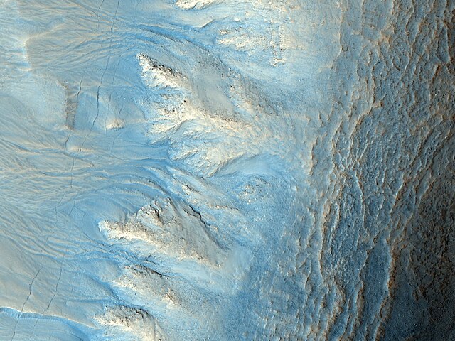
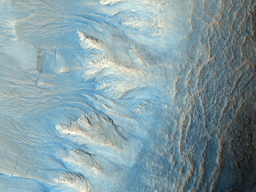
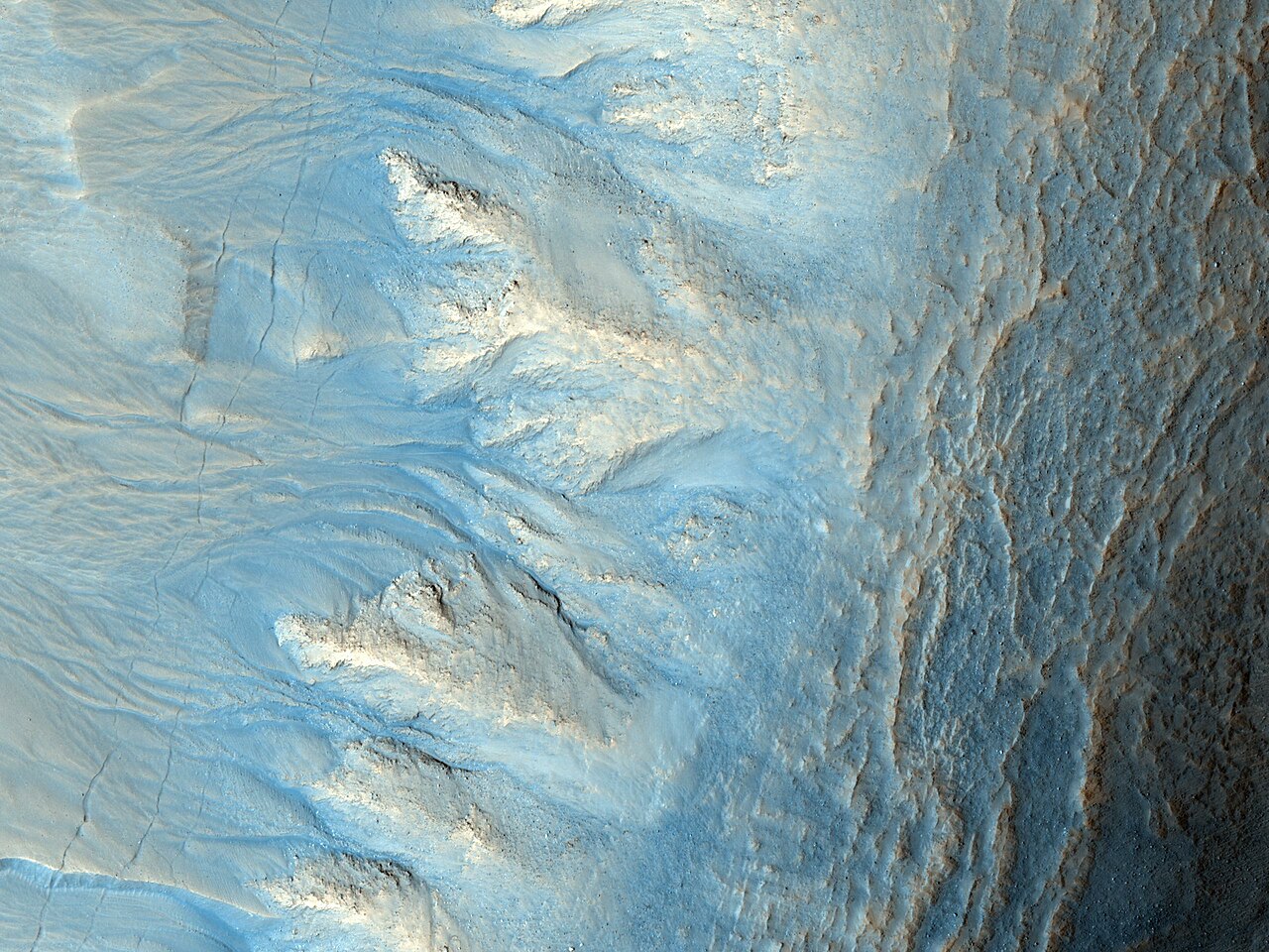
English: This image shows the eastern (west-facing) side of an impact crater in the mid-latitudes of the Northern hemisphere.
Like many mid-latitude craters, this one has gullies along its walls that are composed of alcoves, channels, and debris aprons. The origins of these gullies have been the subject of much debate; they could have formed by flowing water, liquid carbon dioxide, or dry granular flows. The orientation of these gullies is of interest because many craters only contain gullies on certain walls, such as those that are pole-facing. This could be due to changes in orbital conditions and differences in solar heating along specific walls. Many of the other features observed in and around this crater however are indicative of an ice-rich terrain, which may lend credence to the water formation hypothesis, at least for the gullies visible here. The most notable of these features is the "scalloped" terrain in and around the crater. This type of terrain has been interpreted as a sign of surface caving, perhaps due to sublimation of underlying ice. Another sign of ice is the presence of parallel lineations and pitted material on the floor of the crater, similar to what is referred to as concentric crater fill. Parallel linear cracks are also observed along the crater wall over the gullies, which could be due to thermal contraction of ice-rich material. All of these features taken together are evidence for ice-rich material having been deposited in this region during different climatic conditions that has subsequently begun to melt and/or sublimate under current conditions. More recently, aeolian deposits have accumulated around the crater as evidenced by the parallel ridges dominating the landscape. Dust devil streaks are also visible crossing the aeolian ridges. |
| Дата | |
| Источник | HiRISE |
| Автор | NASA/JPL/University of Arizona (Text: Dan Berman) |
Local Mars time: 2:57 PM. Latitude (centered): 46.7 °. Longitude (East): 90.2 °. Range to target site: 305.5 km. Original image scale range: 30.6 cm/pixel (with 1 x 1 binning) so objects ~92 cm across are resolved. Map projected scale: 25 cm/pixel and north is up. Map projection: EQUIRECTANGULAR. Emission angle: 7.7 °. Phase angle: 49.3 °. Solar incidence angle: 42 °, with the Sun about 48 ° above the horizon. Solar longitude: 77.1 °, Northern Spring.
Лицензирование
| Этот файл находится в общественном достоянии (англ. public domain), так как он был создан NASA (Национальным управлением по аэронавтике и исследованию космического пространства). Политика авторского права NASA гласит, что «Материал NASA не защищается авторским правом, если не указано иное». (См. Template:PD-USGov, страницу политики авторского права NASA или политику использования изображений JPL.) | ||
 |
Предупреждения:
|
История файла
Нажмите на дату/время, чтобы увидеть версию файла от того времени.
| Дата/время | Миниатюра | Размеры | Участник | Примечание | |
|---|---|---|---|---|---|
| текущий | 16:14, 10 июня 2010 | | 2560 × 1920 (709 КБ) | Originalwana | {{Information |Description={{en|1=This image shows the eastern (west-facing) side of an impact crater in the mid-latitudes of the Northern hemisphere. Like many mid-latitude craters, this one has gullies along its walls that are compo |
Использование файла
Нет страниц, использующих этот файл.
Глобальное использование файла
Данный файл используется в следующих вики:
- Использование в beta.wikiversity.org
- Использование в en.wikiversity.org
- Использование в pl.wiktionary.org